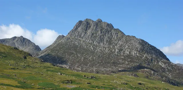
Tryfan
Photo via Wikimedia Commons — licence & author.
Britain's best scramble mountain
This is a quick reference, not a full walked guide. The facts below — location, parking, grid reference and access — are maintained from our dataset, but we haven't published our own first-hand write-up of Tryfan yet. Know it well? Help us get it right.
A 918-metre shark's fin of rock in the Ogwen Valley, and one of the very few mountains in Wales you cannot reach the top of without using your hands. Its North Ridge is Britain's most famous Grade 1 scramble — a continuous, exhilarating clamber with route choices to suit your nerve. On the summit stand Adam and Eve (Sian a Siôn), two stone monoliths about a metre apart; tradition grants the 'freedom of Tryfan' to anyone who leaps the gap, though the drop beyond concentrates the mind. This is serious ground: exposed, committing and treacherous when wet or icy, with no easy walkers' path to the top. Come equipped, in good conditions, and know your scrambling limits.
Getting there
Tryfan is in Ogwen Valley, Eryri (Snowdonia). It's roughly 14 min (3.8 miles) from Capel Curig , and within reach of Bethesda (18 min) and Llanberis (19 min).
The nearest parking: A5 lay-bys below Tryfan (fill by 8am) or Ogwen Cottage. Grid reference SH 664 598 — works on any OS map and doesn't need a phone signal.
Good to know
Confident scramblers only; helmet sensible. Heather Terrace is the easier line. Check weather hard.
On the map
View Tryfan on OpenStreetMap ↗, or open it in the Explore Wales trip planner to add it to a day out with drive times and offline maps.
Staying over?
Capel Curig makes a relaxed base for exploring the area — worth staying over to catch an early start or a golden-hour finish.
Browse places to stay near Capel Curig ↗ opens Booking.com — needs signalNearby places
Make Tryfan part of a day out
Add it to a trip in the free Explore Wales planner — chained drive times, weather, campsite suggestions, and offline maps for when the signal drops.