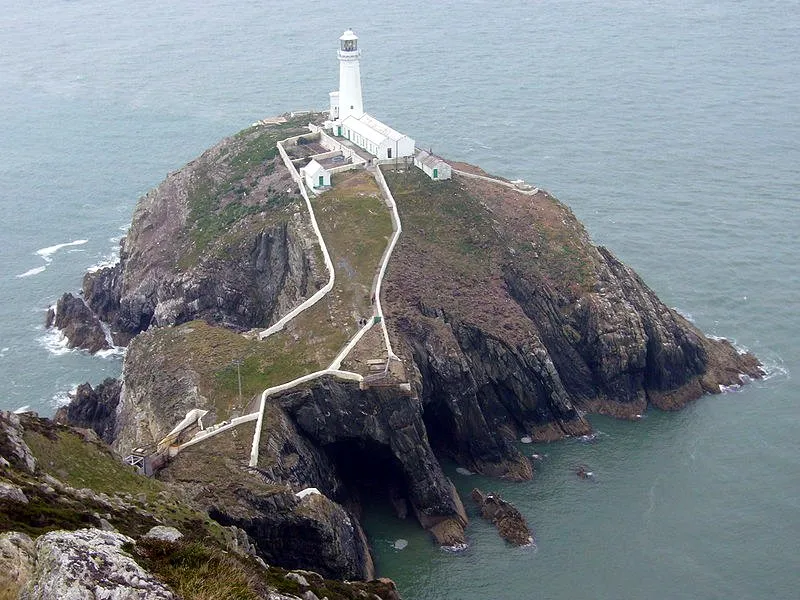
South Stack Cliffs & Lighthouse
Photo via Wikimedia Commons — licence & author.
Seabird cities & the 400 steps
This is a quick reference, not a full walked guide. The facts below — location, parking, grid reference and access — are maintained from our dataset, but we haven't published our own first-hand write-up of South Stack Cliffs & Lighthouse yet. Know it well? Help us get it right.
One of the great seabird spectacles in Wales: sheer quartzite cliffs on Holy Island stacked with guillemots, razorbills, puffins and rare choughs through the breeding season, roughly April to July. The islet of Ynys Lawd is crowned by a lighthouse of 1809, designed by Daniel Alexander and reached by a path of around 400 steps down the cliff and a bridge across the churning gap. The RSPB manages the reserve, and its clifftop lookout, Ellin's Tower, keeps telescopes trained on the colonies. It is also the start of a fine walk up Holyhead Mountain, the highest point on Anglesey. Bring binoculars, a head for heights on the steps, and a windproof — it is exposed out here.
Getting there
South Stack Cliffs & Lighthouse is in Holy Island, Anglesey, Anglesey (Ynys Môn). It's roughly 11 min (2.7 miles) from Holyhead , and within reach of Trearddur Bay (14 min) and Benllech (55 min).
The nearest parking: RSPB South Stack car parks (free/donation). Grid reference SH 206 823 — works on any OS map and doesn't need a phone signal.
Good to know
Puffin season peaks May–June; sunsets here are the best on Anglesey. Lighthouse tour ticketed.
🌟 Best time: Puffins, guillemots & razorbills pack the cliffs — around April–July.
On the map
View South Stack Cliffs & Lighthouse on OpenStreetMap ↗, or open it in the Explore Wales trip planner to add it to a day out with drive times and offline maps.
Staying over?
Holyhead makes a relaxed base for exploring the area — worth staying over to catch an early start or a golden-hour finish.
Browse places to stay near Holyhead ↗ opens Booking.com — needs signalNearby places
Make South Stack Cliffs & Lighthouse part of a day out
Add it to a trip in the free Explore Wales planner — chained drive times, weather, campsite suggestions, and offline maps for when the signal drops.