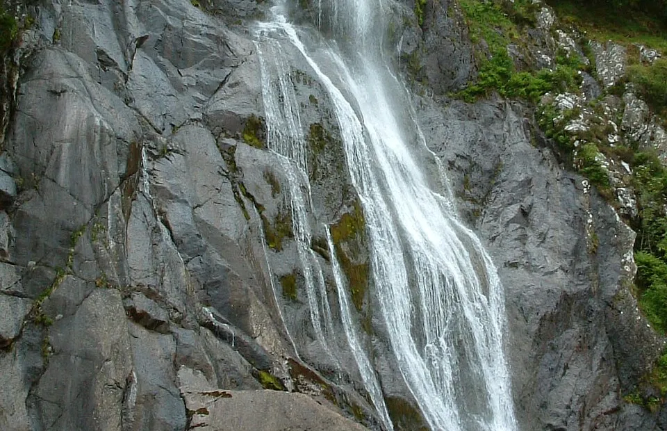
Aber Falls (Rhaeadr Fawr)
Photo via Wikimedia Commons — licence & author.
37m waterfall, easy walk
This is a quick reference, not a full walked guide. The facts below — location, parking, grid reference and access — are maintained from our dataset, but we haven't published our own first-hand write-up of Aber Falls (Rhaeadr Fawr) yet. Know it well? Help us get it right.
Rhaeadr Fawr — the 'great waterfall' — is a 37-metre curtain of the Afon Goch spilling off the northern edge of the Carneddau near the village of Abergwyngregyn. It is one of the best effort-to-reward walks in North Wales: a broad, mostly gentle path of about a mile and a half each way, manageable for families as far as the falls viewpoint. The falls are at their most thunderous a day or two after heavy rain, and freeze into spectacular columns in a hard winter. A quieter sister fall, Rhaeadr Bach, and a longer loop on the North Wales Path reward stronger legs. There is a pay-and-display car park at Bont Newydd and a café near the trailhead.
Getting there
Aber Falls (Rhaeadr Fawr) is in Abergwyngregyn, Conwy & the Coast. It's roughly 14 min (4 miles) from Bethesda , and within reach of Penmaenmawr (16 min) and Beaumaris (21 min).
The nearest parking: Bont Newydd car park, Abergwyngregyn (£; overflow above). Grid reference SH 681 716 — works on any OS map and doesn't need a phone signal.
Good to know
~45 min each way on a good path; loop back via the North Wales Path for Menai views. Busy midday, lovely at 7pm.
🌟 Best time: Winter rain brings the falls to full thunder — around October–March (over winter).
On the map
View Aber Falls (Rhaeadr Fawr) on OpenStreetMap ↗, or open it in the Explore Wales trip planner to add it to a day out with drive times and offline maps.
Staying over?
Bethesda makes a relaxed base for exploring the area — worth staying over to catch an early start or a golden-hour finish.
Browse places to stay near Bethesda ↗ opens Booking.com — needs signalNearby places
Make Aber Falls (Rhaeadr Fawr) part of a day out
Add it to a trip in the free Explore Wales planner — chained drive times, weather, campsite suggestions, and offline maps for when the signal drops.