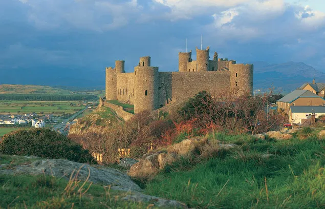
Harlech Castle
Photo via Wikimedia Commons — licence & author.
Crag-top castle of song and siege
This is a quick reference, not a full walked guide. The facts below — location, parking, grid reference and access — are maintained from our dataset, but we haven't published our own first-hand write-up of Harlech Castle yet. Know it well? Help us get it right.
A castle that seems to grow straight out of its crag, with the mountains of Eryri filling the skyline behind it. Built for Edward I between 1283 and 1289 by Master James of St George, it was designed to be supplied from the sea by a fortified stairway — the 'Way from the Sea' — down to water that then lapped the rock; the sea has since retreated, leaving the castle looking out over dunes. Its walls saw the longest siege in British history, held for seven years during the Wars of the Roses and immortalised in the march 'Men of Harlech'; Owain Glyndŵr also captured it and made it his court. A modern 'floating' footbridge now makes a dramatic entrance. Cadw charges admission, and the views from the battlements are among the finest of any Welsh castle.
Getting there
Harlech Castle is in Harlech, Eryri (Snowdonia). It's roughly 0 min (0 miles) from Harlech , and within reach of Criccieth (21 min) and Beddgelert (31 min).
The nearest parking: Castle car park (Bron y Graig Uchaf) or beach car park below. Grid reference SH 582 311 — works on any OS map and doesn't need a phone signal.
Good to know
Best castle-plus-view combo in Wales; the dunes and huge beach below make it a full day.
On the map
View Harlech Castle on OpenStreetMap ↗, or open it in the Explore Wales trip planner to add it to a day out with drive times and offline maps.
Staying over?
Harlech makes a relaxed base for exploring the area — worth staying over to catch an early start or a golden-hour finish.
Browse places to stay near Harlech ↗ opens Booking.com — needs signalNearby places
Make Harlech Castle part of a day out
Add it to a trip in the free Explore Wales planner — chained drive times, weather, campsite suggestions, and offline maps for when the signal drops.